Toronto is one of North America’s most data-forward cities, offering a wide range of public datasets through its Open Data Portal and Geographic Information Systems (GIS) resources. For urban planners, access to such rich, high-quality data is essential in making informed decisions about land use, mobility, housing, environmental sustainability, and more.
This guide explores how urban planners can utilize Toronto’s Open Data and GIS platforms effectively — from understanding what’s available to integrating it into planning workflows and policy development.
1. What Is Toronto Open Data & GIS?
Open Data Portal
The City of Toronto’s Open Data Portal is a public repository of datasets that include everything from traffic counts to zoning maps. It’s organized by category:
- Community Services
- Development & Infrastructure
- Environment & Health
- Government & Finance
- Mobility & Transportation
- Parks, Forestry & Recreation
- Public Safety
- Planning & Development
GIS & Mapping Resources
Toronto also provides extensive GIS files in formats like shapefiles (.shp), GeoJSON, and KML, which can be downloaded and used in desktop software (ArcGIS, QGIS) or web platforms.
2. Why It Matters for Urban Planners
Evidence-Based Planning
Planners rely on demographic, economic, environmental, and spatial data to guide zoning, transit, and housing policies.
Scenario Modeling
GIS tools allow for simulations and visualizations of future land use, development patterns, and transportation models.
Community Engagement
Open data visualizations help make complex planning ideas accessible to the public and stakeholders.
3. Key Datasets Every Toronto Planner Should Know
Zoning By-Law Maps
- Identify permitted land uses, building heights, density.
- Used in rezoning and development application reviews.
Toronto Centreline (TCL)
- Road network data, critical for transportation planning, traffic flow, and accessibility studies.
Property Parcels & Assessment Data
- Lot boundaries, ownership, and tax assessment data support real estate analysis and infrastructure planning.
Building Permits
- Historical and current permit applications help track construction trends and housing supply.
Development Applications
- View active and approved planning applications — useful for neighborhood change assessments.
Demographics by Census Tract
- Population, age, language, ethnicity, and household structure aid in social infrastructure planning.
Tree Canopy & Green Space Data
- Used in climate resilience planning and urban forestry strategies.
Cycling Infrastructure
- Plan, evaluate, and propose cycling infrastructure improvements based on existing routes and gaps.
4. Tools of the Trade: Working with GIS Data
QGIS (Free & Open Source)
Ideal for viewing, analyzing, and editing shapefiles and spatial datasets from the portal.
ArcGIS (ESRI)
A professional GIS platform with extensive analysis and 3D modeling capabilities (used widely in municipalities).
MapTO & Toronto Maps
Interactive tools by the City of Toronto for viewing zoning, planning applications, heritage districts, and more.
Google Earth Pro
Useful for layering KML data over real-world imagery for community presentations and planning charrettes.
5. Sample Workflow: Using Open Data to Plan a Bike Lane Network
- Download cycling infrastructure shapefiles, collision data, and road network files.
- Analyze where gaps exist in cycling infrastructure using overlay analysis.
- Cross-reference with traffic accident data to find unsafe corridors.
- Propose new routes using least-cost path analysis.
- Visualize recommendations in QGIS with demographic overlays to highlight equity concerns.
6. Planning Challenges Solved by GIS
| Challenge | GIS Solution |
|---|---|
| Affordable housing shortages | Map zoning vs. land values to identify potential for intensification |
| Congestion and transit access | Conduct network analysis for optimal transit stop placement |
| Equity and service gaps | Overlay income/demographics with access to services (e.g., parks, clinics) |
| Environmental impact | Model flood risk zones and green infrastructure opportunities |
7. Best Practices for Urban Planners
- Stay Updated: Data is frequently updated — subscribe to data release newsletters from Toronto Open Data.
- Integrate with StatsCan: Combine Toronto’s datasets with Statistics Canada for deeper insight.
- Use Metadata: Read the metadata before using a dataset; it provides essential information on accuracy, source, and update frequency.
- Engage Stakeholders: Use maps and data visualizations to facilitate dialogue with communities and policymakers.
- Document Your Workflows: Ensure reproducibility and shareability of your planning analyses.
8. Ethical Considerations
Urban planners must handle public data with care:
- Protect privacy when dealing with sensitive datasets.
- Be transparent about data limitations and assumptions.
- Ensure equitable planning outcomes by involving underrepresented communities in data-driven decisions.
9. Learning Resources
- Toronto Open Data Portal
- Toronto Maps
- QGIS Training Manual
- ESRI Canada Blog
- Civic Tech Toronto – meetups and civic data projects
Conclusion
Toronto’s Open Data and GIS resources empower urban planners to design smarter, more inclusive, and data-driven cities. From bike lanes to affordable housing strategies, spatial data is the key to navigating Toronto’s evolving urban landscape.
Whether you’re a student, public-sector planner, or private consultant, mastering these tools and datasets can unlock new possibilities for shaping the future of Toronto.
Wildfire GIS map Canada


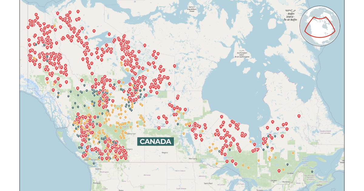
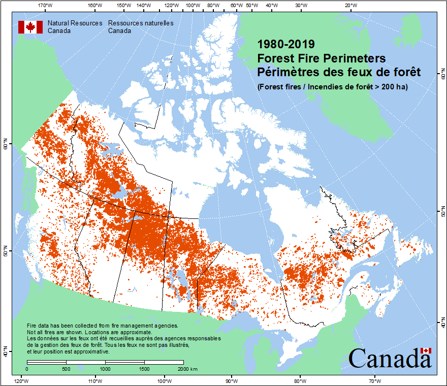
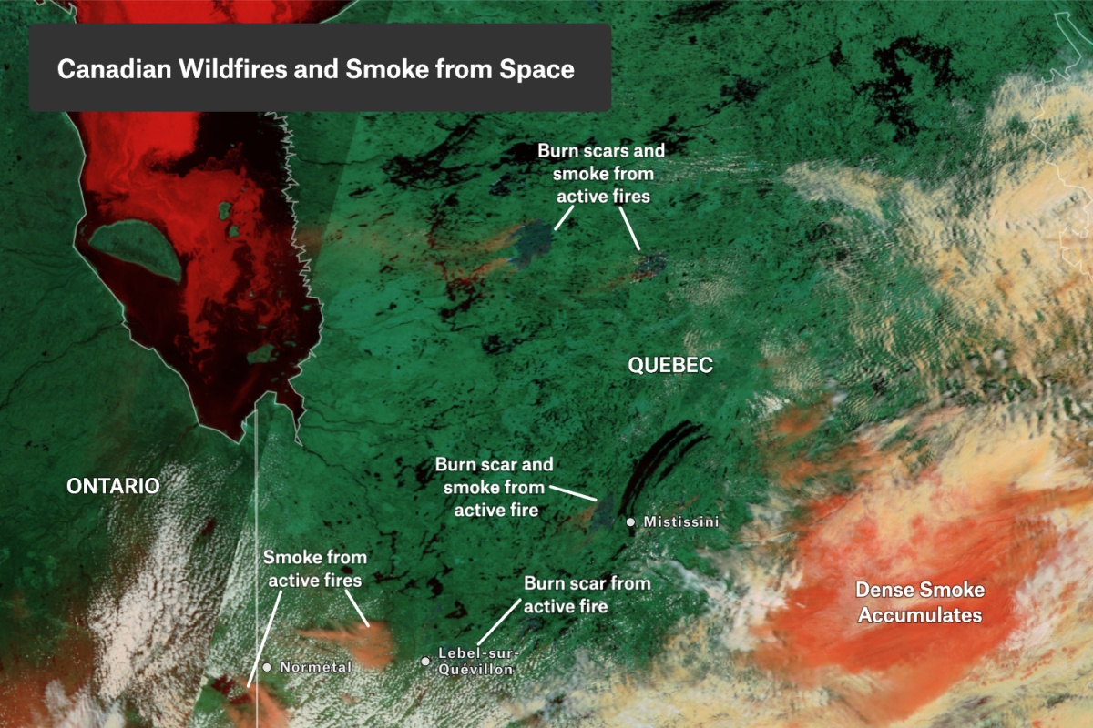
Here are three visuals offering insight into wildfire patterns and smoke mapping across Canada—from historical fire perimeters to current hotspots and satellite imagery.
Canada Wildfire GIS & Mapping Resources
1. Canadian Wildland Fire Information System (CWFIS)
This is Canada’s go-to platform for tracking wildfire activity and risk:
- Offers daily GIS-generated maps including fire weather, fire behavior, and hotspot detection during peak wildfire season.
- Features an interactive map where you can view:
- Season-to-date buffered hotspots (over 1000 ha),
- Fire perimeters, hotspots, and control status of active fires (e.g., out of control, controlled)
- The CWFIS Datamart offers downloadable GIS resources:
- Fire polygon and point data (National Fire Database),
- Burned area composites (since 1972),
- Large fire datasets and hotspot archives
2. ArcGIS Online – Active Wildfire Layers
ArcGIS provides dynamic layers that automatically update wildfire data:
- Active wildfire locations updated every 3 hours, aggregated from provincial, territorial, and federal agencies.
- Active wildfire perimeters, derived from satellite hotspots, displaying current fire extents on a map.
3. NASA FIRMS (Fire Information for Resource Management System)
A global, real-time satellite-based platform:
- Displays active fire detections across Canada (and globally), using MODIS and VIIRS sensors.
- Each detection is interactive—showing coordinates, timestamp, and data source.
4. FireSmoke.ca (BlueSky Canada)
A Canadian portal centered on smoke forecasting and modeling:
- Offers high-resolution forecasts of PM₂.₅ concentrations from wildland fire smoke at ground level.
- Additional tools include Fire Weather forecasts, SmartFire data streams, and the BlueSky Playground, which enables customisable smoke dispersion modelling .
Choosing the Right Map for Your Needs
| Objective | Recommended Platform |
|---|---|
| Real-time wildfire status & hotspots | CWFIS Interactive Map |
| Historical fire perimeters & burned areas | CWFIS Datamart |
| Automated updates in GIS (ArcGIS workflows) | ArcGIS Online datasets |
| Real-time satellite-based fire detections | NASA FIRMS |
| Smoke dispersion modeling & forecasts | FireSmoke.ca |
How to Use These GIS Tools
- CWFIS: Use for daily monitoring, risk assessment, and planning with interactive layers and downloadable data.
- ArcGIS Online: Ideal for GIS professionals working within the Esri ecosystem—good for layered visualizations and custom mapping.
- NASA FIRMS: Perfect for global or cross-border perspectives; integrates easily with GIS tools via standard web services.
- FireSmoke.ca: Supports air quality management, emergency response, and public health monitoring with advanced smoke forecasting.

